Joint Sky Localization (ligo-skymap-combine)
Combine different sky localizations of a common event observed by different instruments in order to form a more constrained localization.
If one of the input maps contains distance information (for instance from BAYESTAR or LALInference) then the marginal distance posterior in the output map is updated according to the restriction in sky location imposed by the other input map(s). Only one input map can currently have distance information.
usage: ligo-skymap-combine [-h] [--version]
                           [-l CRITICAL|ERROR|WARNING|INFO|DEBUG|NOTSET]
                           [--origin ORIGIN]
                           INPUT.fits[.gz] [INPUT.fits[.gz] ...]
                           OUTPUT.fits[.gz]
Positional Arguments
- INPUT.fits[.gz]
Input sky localizations
- OUTPUT.fits[.gz]
Output combined sky localization
Named Arguments
- --version
show program’s version number and exit
- -l, --loglevel
Default:
INFO- --origin
Optional tag describing the organization responsible for the combined output
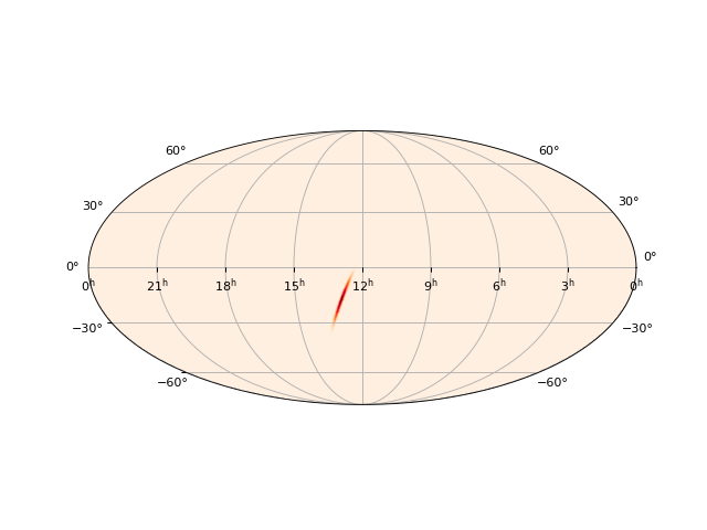
Example
Combine the LIGO-only localization of GW170817 and the Fermi/GBM localization of GRB 170817A into a more precise localization:
$ curl -OL https://dcc.ligo.org/public/0146/G1701985/001/bayestar_no_virgo.fits.gz
$ curl -OL https://gammaray.nsstc.nasa.gov/gbm/science/grbs/grb170817a/gbuts_healpix_systematic.fit
$ ligo-skymap-combine bayestar_no_virgo.fits.gz gbuts_healpix_systematic.fit hanford_livingston_gbm.fits.gz
$ ligo-skymap-plot hanford_livingston_gbm.fits.gz -o hanford_livingston_gbm.png
(Source code, png, hires.png, pdf)